April 30-
1989- Early morning sou'wester caused rain and wind. The actual storm itself was brief. 29 mph was the peak gust.
1990- Soueaster impacted the region at nightfall. Fog was prevalent all day long, and finally came to a head with some light rain. A warm front was the cause of the precipitation.
1991-Another soueaster caused precipitation to fall. This time it stuck around for a bit. The winds were not a problem.
Wednesday, April 30, 2008
Tuesday, April 29, 2008
Monday, April 28, 2008
This date in Noreaster History 4/28
April 28-
1980- A low pressure zone moving to the north of Nantucket. Light rain fell.
1987- A front arrived, and with it, was rain and a NE wind.
1988- Warm front brought showers and severe thunderstorms. No damage was reported.
1997- Low pressure delivers wind and rain. Rain was light. Peak Gust was 46 MPH.
2002- A souseaster grazed the island. Heavy and Light Rain fell, and the peak wind gust was 32 MPH.
2004- Cold front passed Nantucket. Heavy rain fell.
Sunday, April 27, 2008
This date in noreaster history 4/27
April 27-
1973- A soueaster brought thunderstorms and rain. Rain was light in nature.
1978- frontal passage brought light rain and moderate winds.
1991-A noreaster off of Sable Island drew fog and rain off of the ocean. The central pressure of this noreaster, was 990 millibars. No damages or surf was recorded.
1993- An intensifying low pressure system moved off of the coast this AM.
1999- cold front passed off to the east. Light rain fell.
Saturday, April 26, 2008
This date in noreaster history 4/26
April 26-
2003- Intense soueaster delivers a punch. Winds of 50 mph were reported with this system.
2003- Intense soueaster delivers a punch. Winds of 50 mph were reported with this system.
Friday, April 25, 2008
This day in Noreaster History 4/25
April 25-
1974- A continuation of the previous day's event. All stormy weather left the area by 3 PM.
1975- Light rain fell in a northeasterly breeze. Peak gusts were 25 miles per hour. The rain fell at two intervals.
1986- Tail end of previous days system. Peak gusts today were 46 MPH. Rain fell primarily in the morning hours, ending around 10 AM.
1987- powerful frontal passage resulted in winds gusting better than 40 MPH. Light rain fell.
2001- Low pressure zone created rain and wind. Wind was light.
2002- The day was clear. Around 6 o'clock a sou'easter bore down upon Nantucket. The rain fell for just a few short hours. The wind hoever, was another story; as the day progressed the wind swung around from the Southwest to the south and finally the southeast. The highest official gust was 40 mph, but an unofficial gust of 60 mph was recorded from the storm.
Thursday, April 24, 2008
This date in noreaster history-4/24
April 24-
1977- The day was foggy and wet with little wind out of the NE.
1983- An intense Soueaster buffeted the region. Sustained winds were at 58 mph. The low had a central pressure of 992 millibars.
1986- a low pressure area off of the virginia capes brought light rain and winds in the 30s.
1997- Wind and rain were the norm of the day as a coastal storm brought winds in excess of 46 mph. Rainfall was light. No damage was reported.
Wednesday, April 23, 2008
Review of the April 23, 2006 event
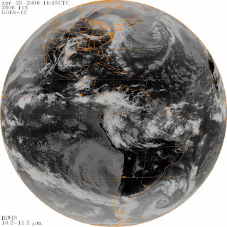
What happened? The storm was centered over Canada, and its trailing front, was reaching down into New England. It seemed that the main action was trying to establish itself. The air appeared to be almost too dry over New England. The rain that fell at 1 AM, was associated with this, but it was dissipating. The low continued to move eastward, and thus the rain became heavier during the evening hours.
This date in Noreaster History 4/23
April 23-
1972- Light rain associated with a cold front fell on the island.
1974-Moderate Souwester ocurred. Rainfall ocurred from 1 AM to just after 2 PM. Fog was prevalent after the rainfall.
1980- A low pressure system south of Nantucket provided ENE winds that were 29 MPH sustained. Gusts to 40 MPH were reported three times. Precipitation was light with the storm, as most of it was over the ocean.
1981- Warm front passed overhead. Precipitation fell starting at 3 PM, and lasting until the late evening hours.
1998- A raw wind out of the east brought heavy rain with it. Rain fell during four periods. The rain was light, and winds were sustained at 34 mph. A peak gust of 46 mph was recorded.
1999- A strong cold front brought heavy rain to the island. No damage was reported from the rain.
2004- a developing low brought a period of light rain to the island. Wind gusts to 31 mph were recorded at 10:53 AM. It was clear only once during the day, and that was late evening.
2005- A soueaster brought rainfall to the island. The wind was not a factor with this storm. The skies finally cleared around 7 PM.
2006- While there was a period of light rain around 1 AM, the main action would come later. In fact, the skies were clear until the 9 AM hour. The skies became overcast again, and at 1:30 PM, light rain fell. The skies cleared again, and at 6:30 PM, light rain began to fall. The rain became heavier as the night progressed. Wind was sustained at 30 mph. A peak gust was 44 mph.
Tuesday, April 22, 2008
This date in noreaster history 4/22
April 22-
1985-Cold front passes island. Thundershowers ocurred around 2 PM
1987- Dry noreaster ocurred. Clouds and wind,
1985-Cold front passes island. Thundershowers ocurred around 2 PM
1987- Dry noreaster ocurred. Clouds and wind,
Monday, April 21, 2008
On this date in noreaster history-4/21
April 21-
1984-Strong cold front passes overhead. 40 mph wind gusts were recorded.
1991-Sou'easter passes nearby. Rain and strong winds were the norm for the day. The rain ended by 2 PM, but the residual effects remained well into the evening hours.
1984-Strong cold front passes overhead. 40 mph wind gusts were recorded.
1991-Sou'easter passes nearby. Rain and strong winds were the norm for the day. The rain ended by 2 PM, but the residual effects remained well into the evening hours.
Saturday, April 19, 2008
This date in noreaster history-4/20
April 20-
1998- A low pressure zone passes north of the island. Southwest wind is reported, along with heavy rainfall.
1998- A low pressure zone passes north of the island. Southwest wind is reported, along with heavy rainfall.
On this date in noreaster history 4/19
April 19-
1974- Frontal passage brings NE winds and rainfall.
1978-Soueaster began after nightfall. Rain was the norm.
1983-Another soueaster affected Nantucket, the morning was a windy one, and precip didn't fall until after four o'clock that afternoon.
1997- Strengthening noreaster brought light rain and 40 MPH sustained wind. Maximum gusts were 58 mph.
Friday, April 18, 2008
Today in noreaster history 4/18
April 18-
1986- weak coastal storm brings light rain, and winds out of NE. Peak gust was 48 mph.
1987-Soueaster brought rain and fog.
1991-Strong cold front traversed area. Bringing rain and wind.
1992- the day had dawned overcast, and by nightfall light rain fell.
2001- Area of light rain passed overhead.
2006-the second day of a coastal storm. Rain and wind were the norm today.
2007- A secondary area of low pressure passed overhead. Nantucket, was still reeling from the last three days of the Tax Day storm.
Thursday, April 17, 2008
Today in Noreaster history 4/17
April 17-
2006- Weak developing coastal system affects Nantucket.
2007-An outer band of the Tax Day noreaster hits Nantucket. Winds were sustained at 32 MPH. Gusts to 41.
2006- Weak developing coastal system affects Nantucket.
2007-An outer band of the Tax Day noreaster hits Nantucket. Winds were sustained at 32 MPH. Gusts to 41.
Wednesday, April 16, 2008
This day in Noreaster History 4/16
April 16-
1975-Fast moving system dropped rain and snow on Nantucket.
1989- Tail end of previous day's system. Peak wind gust was 48 miles.
1992- Southeast storm brought snow to Nantucket. It would change to all rain some time in the pre dawn hours of the next day.
1996-Coastal Storm brought winds of 34 MPH. The rain began to fall at 10 AM. Peak gust was 46 mph.
2007- The second day of the April 2007 noreaster. Rain fell for a good portion of the day. Esther's Island; part of Smith's Point became severed from the rest of Nantucket. The storm "Departed" later that afternoon.
Tuesday, April 15, 2008
Review of the 2007 noreaster
The infamous April 2007 noreaster will, go down in Noreaster History, after the Perfect Storm of 1991 as one of the strongest noreasters of all time.
It began as an upper level disturbance over California and Arizona. Rapidly, it moved over the country, and on the 13, it moved over the Gulf Stream. After moving off the coast, it bombed out. The storm's center moved to a position off of New Jersey. The pressure was at 969 millibars, 16 millibars lower than that of the Perfect Storm. The winds associated with this noreaster, were intense, with 75 mph gusts.
The effects on Nantucket were just as bad as those felt on the mainland. Trees, some close to one hundred years old, were felled by the winds. The Jared Coffin House, had a tree fall onto it. The wind was measured at 60 MPH, with some higher gusts.

Formation of Noreaster

Noreaster off of coast

Peak
It began as an upper level disturbance over California and Arizona. Rapidly, it moved over the country, and on the 13, it moved over the Gulf Stream. After moving off the coast, it bombed out. The storm's center moved to a position off of New Jersey. The pressure was at 969 millibars, 16 millibars lower than that of the Perfect Storm. The winds associated with this noreaster, were intense, with 75 mph gusts.
The effects on Nantucket were just as bad as those felt on the mainland. Trees, some close to one hundred years old, were felled by the winds. The Jared Coffin House, had a tree fall onto it. The wind was measured at 60 MPH, with some higher gusts.
Formation of Noreaster
Noreaster off of coast
Peak
This date in Noreaster History 4/15
April 15-Tax Day.
1989- A sou'easter took hold. The day began foggy. By midnight on the 16th, Light rain was falling.
1991-Warm front lifted northward. Rain fell.
2007- The beginning of the infamous "April 2007 Nor'easter." The day itself actually dawned clear, but around 9 AM the clouds and precip overspread the area.
Monday, April 14, 2008
On this date in Noreaster history-4/14
April 14-
1996-Developing Low Pressure area delivered light drizzle and 40 mph winds.
2004- The back side of a coastal storm delivered heavy rain and a peak wind gust of 33 MPH.
1996-Developing Low Pressure area delivered light drizzle and 40 mph winds.
2004- The back side of a coastal storm delivered heavy rain and a peak wind gust of 33 MPH.
Saturday, April 12, 2008
On this date in Noreaster History
April 13
1982-Sou'wester. Rain and wind. Max wind gust was 44 mph.
1987- The day began with winds out of the east, with light rain. The rain mixed with snow at times. The max wind gust was 40 mph. The wind shifted NE around 8 AM.
1993- A small frontal impulse brought fog and rain. Peak windgust was 29 mph.
1982-Sou'wester. Rain and wind. Max wind gust was 44 mph.
1987- The day began with winds out of the east, with light rain. The rain mixed with snow at times. The max wind gust was 40 mph. The wind shifted NE around 8 AM.
1993- A small frontal impulse brought fog and rain. Peak windgust was 29 mph.
Friday, April 11, 2008
This day in Noreaster History 4/12
**Sorry that this is a day early, I have to work**
April 12, is just as important as any other day during Nor'easter Season. Coastal storms, while they are frequent, are becoming more of a frontal passage type event.
1993-Weak cold front passes the island. The frontal band itself contained rain and fog. Rainfall was light.
1999- More of a sou'wester than noreaster. The tail end occured later that morning. It began as Light rain. Wind was not a problem with this storm.
2004- Weak coastal storm dumps rainfall on Nantucket.
2005-Snow fell in the pre-dawn hours.
2007-Sou'easter dumps rain on Nantucket. Winds were 41 MPH at their highest.
This day in noreaster history-4/11
April 11- Today the noreaster season is on its last legs.
1988- Coastal storm lashes Nantucket. Peak windgust of 40 was recorded at 5 PM. The main precipitation was rain.
2003- Small frontal type system brushes Nantucket. Rain.
1988- Coastal storm lashes Nantucket. Peak windgust of 40 was recorded at 5 PM. The main precipitation was rain.
2003- Small frontal type system brushes Nantucket. Rain.
Thursday, April 10, 2008
This day in Noreaster History 4/10
April 10, is part of noreaster season. It is also the beginning of Sou'wester season.
1984-Winds were out of the NNE. Snow fell at 5 PM.
1988- Tail end of a weak coastal storm. Clouds only.
1998- Tail end of strengthening storm. Highest winds were measured early this morning, at 63 MPH. Rain and snow fell.
2001-Cold front passed overnight, producing light rain showers.
1984-Winds were out of the NNE. Snow fell at 5 PM.
1988- Tail end of a weak coastal storm. Clouds only.
1998- Tail end of strengthening storm. Highest winds were measured early this morning, at 63 MPH. Rain and snow fell.
2001-Cold front passed overnight, producing light rain showers.
Wednesday, April 9, 2008
Review of the April 9-10th 1998 noreaster

The event of the 9th and 10th was a night event. I do not have pictures of this event. Nantucket awoke on the morning of the 9th to overcast conditions. Throughout the day the winds grew steadily out of the Northeast. Around 4 o'clock the first major gusts occurred, these were at 23 MPH. The first rain drops fell at 5:30 PM, and grew steadier as the evening progressed. By the late evening hours, the rain fell heavily, and the peak wind gust for the 9th, 41 mi/hr, occurred just before Midnight.
Throughout the early hours, the wind grew steadily, and the highest gust recorded from the system occurred around 3 AM on the 10th. The rain kicked over to snow around 2 AM on the 10th. No accumulation was measured from the storm. The storm left the region quickly, and by 1 PM on the 10th.
There were no damages reported on the island. There was school on the 10th, despite the forecast for snow. Temperatures were too warm for snow to stick. The center passed over the island, and the deepest pressure, was 985 millibars.
On this date in noreaster history
April 9: KACK
April 9, is normally near the end of the season for nor'easters, however there are a few standouts.
1976-small coastal storm brought 40 MPH winds and rainfall.
1983-A "dry" nor'easter occurred, the forecast was clouds.
1984-Snow occurred. Winds were out of the NNE. Max winds were 37 mph. no accumulation.
1996- mild nor'easter occurred, rain and snow fell. No accumulation.
1998- While the day began overcast, and calm; Nightfall brought winds of 40+mph and heavy rain.
how this works.

I promise to be committed to this blog. I really do. I'm sorry about the other blogs,but this one, will be about my passion for the weather of Nantucket, and the New England Area.
New England, is in nor'easter alley. The winter may be a time for snow, but on the coast, sleet and freezing rain is the norm, occasionally there will be a heavy snowfall, but that is rare.
Subscribe to:
Posts (Atom)
